Trails Attractions - Gold Coast QLD

ATTRACTIONS TRAILS
Find Trails Attractions in , search things to do and see in your holiday location with Gold Coast QLD.

Josephine Falls walking track, Wooroonooran National Park Logo and Images

Josephine Falls walking track, Wooroonooran National Park

Josephine Falls Walk, Wooroonooran QLD 4860
Josephine Creek starts as a gentle trickle high on the summit of Queensland's highest mountain, Bartle Frere. By the time it has travelled the 7.5 kilometres to the smooth granite boulders of Josephine Falls, it is a thundering torrent that will take your breath away. Enjoy the 1.2 kilometre return walk through lush, world heritage-listed rainforest to viewing decks over the picturesque falls. Slip into the bottom pool for an icy dip and then warm up on the smooth granite boulders after your swim Josephine Falls is an extremely refreshing place to visit—but it is also potentially dangerous. Flash flooding (rapidly rising water) is common during wetter months. Rapid and unpredictable water level rises have isolated people on the far bank requiring their rescue. For your safety, access to the top section of the falls is prohibited. Please keep out of the signposted restricted access area, as serious injuries and deaths have occurred here. Penalties apply. Obey all safety signs and only swim in the designated area. Never jump or dive into water—there may be submerged objects. Leave the water immediately if it changes colour or the water levels rise—these are signs of flash flooding....
Churches of Bundaberg Logo and Images

Churches of Bundaberg

36 Avenue Street, Bundaberg East QLD 4670
Starting off at the graceful Holy Rosary Catholic Church on Barolin Street this walk will take in the spectacular architecture and history of the Churches located in Bundaberg. This walk includes Churches of all different faiths. This walk takes in the Bundaberg Uniting Church, Salvation Army Church, Restored Apostolic Mission Congregation as well as the Heritage Christian Centre and the Pentecostals of Bundaberg centre. Further details on these buildings are available at the local Visitor Information Centre which can be found at 36 Avenue Street, Bundaberg East....
Freshwater Creek Track, Byfield National Park Logo and Images

Freshwater Creek Track, Byfield National Park

Byfield National Park, Farnborough QLD 4703
With its rugged pinnacles, tucked-away camping spots, spectacular sand dunes and picturesque stretches of coastline, the Byfield National Park is a remote coastal getaway. Massive parabolic sand dunes—the oldest reaching 5 to 6 kilometres inland—occupy most of the southern part of the park. In the north, the rugged pinnacles of The Peaks and Mount Atherton dominate the landscape. From Nine Mile Beach, park at the mouth of Freshwater Creek and stroll 250 metres to picnic among shady she-oaks beside the creek. Take a towel for a freshwater splash along the way. The track entrance is 400 metres south of Nine Mile Beach Access Track/Junction 19). You need only 30 minutes walking time for this walk....
Morelia walking track, D'Aguilar National Park Logo and Images

Morelia walking track, D'Aguilar National Park

Manorina, Mount Nebo QLD 4520
The Morelia walking track is in southern D'Aguilar National Park. Starting from Manorina, this walk explores patches of cool rainforest and open eucalypt forest before reaching Mount Nebo lookout. Discover wet eucalypt forest and groves of cabbage tree palms, their huge fan-shaped leaves spreading overhead like umbrellas. Listen for the booming ‘wallock-a-woo’ and ‘book-a-roo’ call of wompoo fruit-doves calling in the canopy. Catch your breath at the natural rock outcrop of Mount Nebo lookout and admire magnificent views over Samford Valley, Mount Tempest and Moreton Bay. On a clear day, the Moreton Island sand dunes appear to strangely hover on the horizon. If you're keen to keep walking, Manorina is also the starting point for the short and family-friendly Atrax circuit. This six kilometre return walking track is mostly gently-sloping and well-defined track but it is quite steep in some places. Return along the same track. You need about two hours to complete this moderately difficult grade track....
Federation Walk Logo and Images

Federation Walk

Philip Park, Main Beach QLD 4217
Federation Walk is a 3.5 kilometre pedestrian walkway located on a natural section of the area known as The Spit. Federation Walk begins at a fig tree in the parking lot opposite the entrance to Sea World. The walk continues through patches of rainforest where regular community planting days are held. After leaving the Federation Walk Coastal Reserve, the walk continues under the sand bypass jetty and along the pathway to the southern training wall of the Gold Coast Seaway. The tip of the walk is at the end of the Gold Coast ocean way from where you can take in spectacular views of the coastline. The Federation Walk Coastal Reserve is one of the few remaining areas of undeveloped dune system on the Gold Coast and is part of a regionally significant corridor of coastal vegetation. A network of established paths and tracks throughout this beautiful reserve allow for hiking, jogging, cycling, birdwatching or simply sitting under the trees and listening to the birds singing accompanied by the sounds of the ocean....
Eddie Santaguiliana Way Logo and Images

Eddie Santaguiliana Way

Eddie Santagiuliana Way, Cleveland QLD 4163
Looking for a walking or cycling trail that’s jam-packed with natural wonders? You need look no further than Eddie Santagiuliana Way on Redlands Coast. This foreshore trail snakes its way from Cleveland to Thornlands and allows you to appreciate nature as you walk or cycle along the shady track. Chances are you will be able to spot a koala in the wild along the ever-changing route, or in one of the adjacent parks. You’ll see wetlands and creeks, mangroves, bushland and other vegetated areas. And then there are breath-taking coastal views over Moreton Bay. You may opt to stop off for a few minutes for a rest and visit duck ponds, or the children’s playground for some extra fun. There are drinking fountains along the way for those who forget their water bottles and toilet facilities. The track, which is relatively flat and features concrete pathways and boardwalks that take you through a variety of habitats, is perfect for children or those of us who are not so fit! It is well signed with interesting information about the wildlife and flora of the area, allowing you to learn more about the natural wonders you are experiencing. Eddie Santagiuliana Way really is a wildlife lover’s paradise....
Carole Green Walkway - John Oxley Reserve Logo and Images

Carole Green Walkway - John Oxley Reserve

Ogg Road, Murrumba Downs QLD 4503
Enjoy the natural and cultural history of Carole Green Walkway at John Oxley Reserve. The trail starts at the John Oxley Reserve car park and heads towards the North Pine River, where a boardwalk lets you experience the mangroves and cultural sites of significance. Take the time to read the signage and learn about all of the areas natural assets and it's pioneering past. You can also do some nature spotting along the way, with possums, birds and tree snakes calling this location home....
Kondalilla Falls Circuit, Kondalilla National Park Logo and Images

Kondalilla Falls Circuit, Kondalilla National Park

Kondalilla National Park, Montville QLD 4560
Explore this beautiful walking track that leads from Kondalilla Falls down the escarpment into a lush rainforested valley then climbs up the ridge again to return. From the Kondalilla Falls car park, walk 100-metres downhill (with steps) to a large grassed picnic area with barbecues, picnic tables and toilets. Laze over a picnic then set out for a scenic walk. Follow the Picnic Creek circuit, walking through rainforest and open forest to a cool rock pool at the top of the falls. Continue on the Kondalilla Falls circuit, descending into lush rainforest as you walk down to the valley for the best waterfall view at the base of the falls. What goes down must come back up! As you climb the ridge, look for emergent bunya pines with their distinctive symmetrical dome shapes, dense stands of piccabeen palms and intriguing shapes of pink ash. There are over 300 stairs on the Kondalilla Falls circuit so you need to be reasonably fit and allow enough time to enjoy this steep walk. Leave enough time to complete your walk in daylight hours. This walk is a Grade 3 track (formed track, may have short steep hills and many steps, some experience recommended)....
Sunset Track Logo and Images

Sunset Track

Baldwin Swamp Conservation Park, Bundaberg QLD 4670
Fondly referred to as Bundaberg's own slice of Kakadu with its lush wetlands, abundant birdlife and fish breeding habitats, Baldwin Swamp provides a range of authentic wetland experiences, right in the heart of the city. Only five minutes from the Bundaberg Central Business District, the conservation park has nearly a one kilometre series of walkways that wind through the park. Take a punt at picking out some of the 75 species of waterbirds that call the swamp home. Baldwin Swamp isn't just perfect at sunset - you can visit anytime of the day and at night you might encounter Possums, Bandicoots and the ever elusive Echidna foraging for their dinner. ...
Kholo Gardens Trails Logo and Images

Kholo Gardens Trails

243 Riverside Drive, Muirlea QLD 4306
Kholo Gardens is one of the best kept secrets in Ipswich. Established in 1988 on a historically significant site, it is today one of the most welcoming and beautiful parks in Ipswich. Featuring almost 40 hectares of stunning grounds, walking tracks and boardwalks meander along creek lines, through sub-tropical rainforest and even down to the banks of the Brisbane River. Giant Kauri and Hoop Pine trees planted by early settlers tower over the gardens, while a nearby soothing waterfall cascades into the still coolness of the lily pond. Some rarely seen species of local flora and fauna can be found at Kholo. It is a haven for plant-lovers and bird watchers alike. Those with a love of Nature will enjoy the chance of seeing a Grease Nut Tree (Hernandia bivalvis), or the possibility of spotting a Tusked Frog, Great Crested Grebe, or maybe even a large Powerful Owl. Remnant vine thicket merges into rehabilitated dry rainforest, a palm grove, Eucalypt forest and expansive open areas to provide an assortment of habitats for local fauna. There is also a charming waterlily pond, complete with its own resident family of ducks....
Kennedy Walking Track Logo and Images

Kennedy Walking Track

Kennedy Esplanade, South Mission Beach QLD 4852
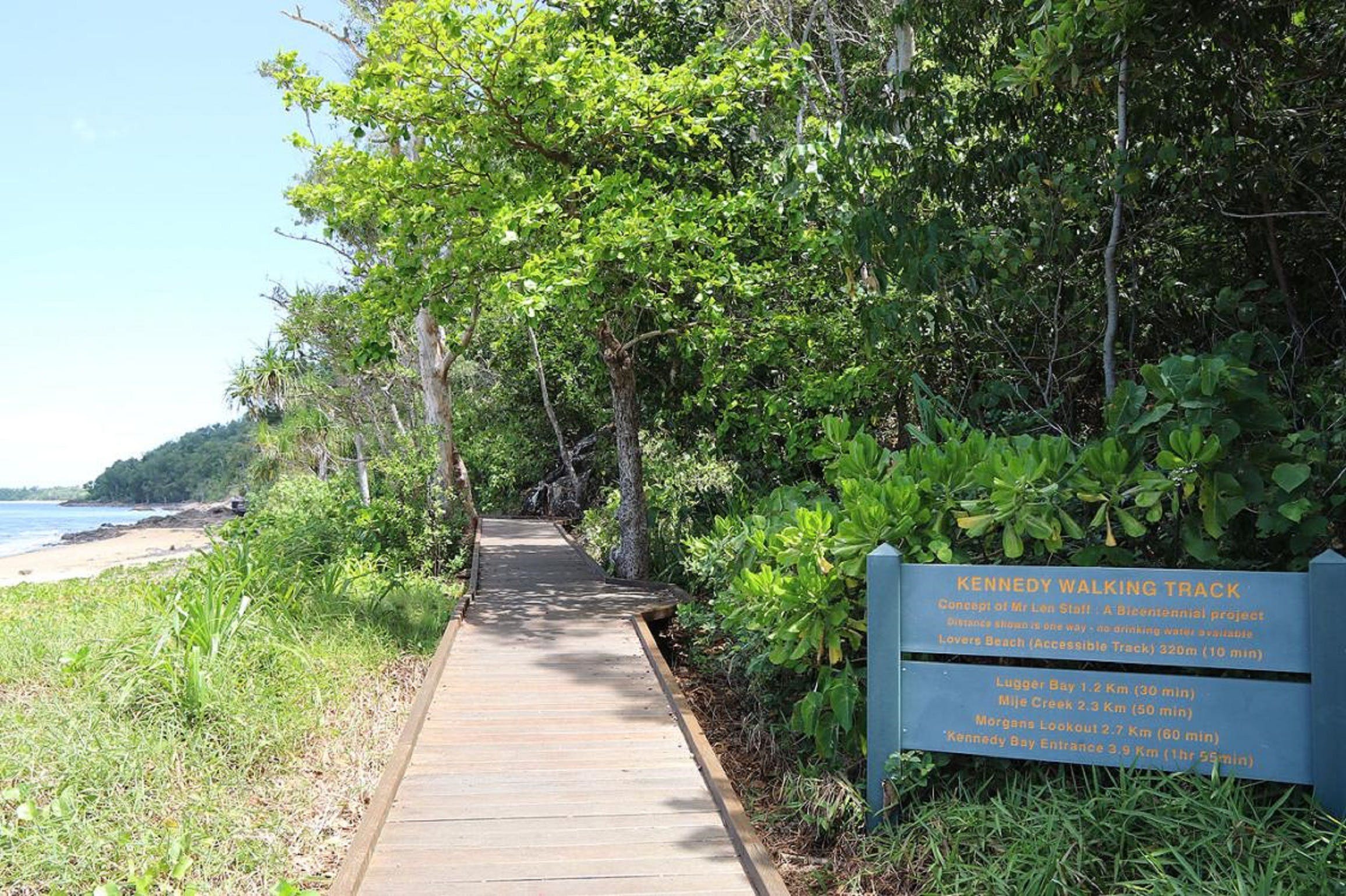
This popular coastal trail is an enjoyable and picturesque four kilometre (one way) route that includes beach and forest walking as well as island views. The track cuts through a wide variety of coastal rainforests to get to beaches and rocky headlands. It offers great views of the Family Group of Islands and the chance to see cassowaries, wallabies and other rainforest animals. Peer down into the ocean from lookout points to spot turtles, dugongs and dolphins. The Kennedy Walking Track takes you from South Mission to Kennedy Bay, past the landing place of 1848 explorer Edmund Beasley Court Kennedy. If you have the time you can then walk the length of Kennedy Bay along the beach to finish at the Hull River. The communities of Hull and Tully Heads are on the other side. Return is via the same pathway. This trail is suitable for a wide range of walkers, although the second half includes more stairs and a bit of rock-hopping. There is a wide boardwalk to the first beach, known as Lover's Beach....
Haig Street Quarry Bushland Reserve Trails Logo and Images

Haig Street Quarry Bushland Reserve Trails

39 High Street, Brassall QLD 4305
Located an easy five minutes drive from Ipswich Central, the Haig Street Quarry Bushland Reserve offers a family friendly setting with spectacular views of the Scenic Rim. Bring a picnic and enjoy the beautiful wildflower display in spring, moderate level walking tracks along with Willy Wagtail and Bearded Dragon circuits, and the water birds around the pond....
Bluewater Trail Logo and Images

Bluewater Trail

River Street, Mackay QLD 4740
See highlights of Mackay along the Bluewater Trail, a shared bicycle and pedestrian walkway which connects art, historic architecture and points of interest with natural beauty. The Bluewater Trail is approximately 20 kilometres in length, linking key attractions, including the picturesque Mackay Regional Botanical Gardens and the Bluewater Lagoon to Mackay's natural features, the Pioneer River and Town Beach. A feature along the trail is the inclusion of six public art installations, each uniquely representing a piece of Mackay's history and diversity. The public art can be viewed along Bluewater Quay. More impressive public art can be seen above the bank of the Pioneer River. The Catherine Freeman walk crosses over the wetland adjacent to the Pioneer River and links Mackay's Central Business District with the Botanical Gardens. The Sandfly Creek Environmental walk stretches from Bluewater Quay, where another fishing pier can be found, and makes its way across grassland toward the Pioneer River mouth, before turning to head toward Town Beach. This conservation area is popular with bird-watchers. The Bluewater Trail includes the popular Bluewater Lagoon, a three-tier swimming facility with waterslide. Entry is free and lifeguards monitor the pools....
Oceanview Walk, Burleigh Head National Park Logo and Images

Oceanview Walk, Burleigh Head National Park

Burleigh Head National Park, Burleigh Heads QLD 4220
Ancient volcanic columns meet the sea on this easy stroll in Burleigh Head National Park in the heart of the Gold Coast. The Oceanview track skirts the coastline leading around the rocky headland from the southern edge of Burleigh Heads township to the southern [park entrance near Tallebudgera Creek. Pack a picnic and relax by the creek at Echo Beach and marvel at the tumbled masses of six sided basalt columns. Spot whales (during winter and spring), white-bellied sea-eagles and birdwing butterflies (in summer). Allow 30 minutes from the rocky headland at Tallebudgera Creek to walk the track through pandanus groves, tussock grasslands, coastal heath and mangroves to southern Burleigh. You can either return by the same path or via the Rainforest circuit and Tumgun lookout. For your safety, a section of Oceanview walk may be temporarily closed before, during and after severe weather, due to the increased risk of rock falls. Check Park Alerts for track closures. For your safety, please observe the DANGER boulder fall zone restricted access area sign and remain on the walking track. Access is not permitted to the boulder fields, including Cannon Rock, or the steep slopes between the Oceanview track and the boulder fields—penalties apply....
Misty Mountains Wilderness Tracks Logo and Images

Misty Mountains Wilderness Tracks

Tully Falls Road, Ravenshoe QLD 4888
Delve deeply into the Wet Tropics World Heritage Area along the 130 kilometre network of the Misty Mountains wilderness tracks. The world heritage area is famed for its exceptional natural beauty, outstanding examples of the record of life, evolutionary history and remarkable diversity. Discover lush, high altitude rainforest dotted with crystal clear creeks, stunning waterfalls and panoramic views. The Misty Mountains wilderness tracks extend from the coastal plain to the tablelands. Four long tracks—the Koolmoon Creek, Cannabullen Creek, Cardwell Range and Gorrell tracks—make up the Misty Mountains wilderness tracks. Tackle a long hike or explore smaller fragments of the tracks. Some tracks are suitable only for bushwalkers, while others are shared tracks with mountain biking permitted. Tracks are remote and can be indistinct with encroaching vegetation. Always check Park alerts for latest conditions before you plan your visit. Seven small camping areas (with no facilities) are provided at specific sites along the tracks. Camping permits are required....
Tibrogargan circuit, Glass House Mountains National Park Logo and Images

Tibrogargan circuit, Glass House Mountains National Park

Barrs Road, Glass House Mountains QLD 4518
The Glass House Mountains National Park is known for its craggy peaks that tower above the surrounding landscape. Mount Tibrogargan is located between Beerburrum and Glass House Mountains townships, off Marshs and Barrs Roads. The Tibrogargan circuit (1 kilometre to the Mountain View lookout, 4.1 kilometres for the complete circuit) begins from the northern end of the Mount Tibrogargan car park. A short walk (10mins) leads up to the Mountain View lookout with views over Mount Beerwah, Mount Coonowrin, Mount Tibberoowuccum and Mount Tunbubudla. then continue on the circuit walk around the base of Mount Tibrogargan through casuarina groves, open eucalypt and melaleuca forests. The track provides some great views of Mount Tibrogargan. Peregrine falcons are often seen soaring above this area. Allow about one and a half hours to complete this circuit of a moderate grade. Allow ten minutes if you prefer to walk only to Mountain View lookout....
Best of All lookout track, Springbrook National Park Logo and Images

Best of All lookout track, Springbrook National Park

Repeater Station Road, Springbrook QLD 4213
Springbrook National Park has breathtaking lookouts, magnificent waterfalls, dense rainforest and ancient Antarctic beech trees. The park is part of Gondwana Rainforests of Australia World Heritage area. In the Springbrook Plateau section of the park, several vantage points on the plateau provide extensive views of the surrounding ranges, foothills and the coastline. Constructed lookouts, providing safe viewing, are easily accessible via a short walk. On the Best of All lookout track, venture through ancient Antarctic beech forest to a view of northern New South Wales dominated by Mount Warning, the lava plug at the centre of the erosion caldera of the extinct Tweed shield volcano. The small pocket of Antarctic beech (Nothofagus) forest is one of our remaining links to the ancient forests of Gondwana that occurred here during a past cooler climate. Nothofagus forests were once widespread across the continent and provided a habitat for many animals that have long since disappeared from our landscape. These lookouts are often shrouded by cloud, even when the weather is fine and sunny on the coast. For the best views, visit on clear, smoke-free days....
Maranoa Region Drive Trails Logo and Images

Maranoa Region Drive Trails

2 Riggers Road, Roma QLD 4455
They invite you to explore even more of their region with this series of eight exciting drive trails. Each suggested itinerary has been created by theme, though they encourage you to mix and match according to your interest, location and length of stay. Please note that total distances for each drive should be used as an approximate indication only....
Mount Ngungun summit walking track, Glass House Mountains National Park Logo and Images

Mount Ngungun summit walking track, Glass House Mountains National Park

Fullertons Road, Glass House Mountains QLD 4518
The Glass House Mountains National Park is noted for its distinctive craggy peaks that tower above the surrounding landscape. Formed by volcanic activity millions of years, these ancient rocky outcrops are of special significance to the Gubbi Gubbi Aboriginal people. The Mount Ngungun summit walking track is a 2.8 kilometre trail that begins in open forest and offers great views of Mount Tibrogargan, Mount Coonowrin and Mount Beerwah from the summit. Don't forget to pack your camera as you'll find a 360 degree panoramic view of the coast and hinterland at the top! Listed as a Grade 4 walking track, you will need to have a moderate level of fitness for this track, which will take about two hours to complete. Be sure to take plenty of water, wear supportive boots and sun protection. Caution: This track passes close to cliff edges so please supervise children closely. Take extra care around the summit area in wet weather as rocks can become very slippery....
Brisbane Valley Rail Trail Logo and Images

Brisbane Valley Rail Trail

Brisbane Valley Highway , Fernvale QLD 4306
Explore the great outdoors and uncover treasures along Australia's longest recreational rail trail, The Brisbane Valley Rail Trail. The trail follows the old Brisbane Valley Railway line for 161 kilometres from Wulkuraka to Yarraman. The trail is a mecca for mountain bikers, horse riders, hikers and dog walkers who enjoy the excitement of experiencing a range of environments. Along the journey, rail trailers experience a range of rural landscapes, creek crossings and historic landmarks. As the Brisbane Valley Rail Trail takes in many of Somerset's towns, visitors can choose how much or how little of the trail they would like to experience. The original rail line was built in the 1880's to transport timber, milk and beef to Brisbane and supply farmers and towns along the railway line. Brisbane Valley Rail Trail sections: Wulkuraka to Fernvale – 23 kilometres. Fernvale to Lowood – 8 kilometres. Lowood to Coominya – 12 kilometres. Coominya to Esk – 24 kilometres. Esk to Toogoolawah – 19 kilometres. Toogoolawah to Harlin -14 kilometres. Harlin to Moore – 13 kilometres. Moore to Linville – 7 kilometres. Linville to Bernarkin – 17k kilometres. Bernarkin to Blackbutt – 5 kilometres. Blackbutt to Yarraman – 19kilometres....
Whitsunday Ngaro Sea Trail, Whitsunday Islands National Park Logo and Images

Whitsunday Ngaro Sea Trail, Whitsunday Islands National Park

Whitsunday Islands National Park, Whitsundays QLD 4802
***NOTE: as a response to COVID-19, all camping areas in Queensland's national parks are closed to the public until further notice. Check park alerts for updates. Discover your own slice of tropical paradise on the Whitsunday Ngaro Sea Trail, a unique blend of seaways and picturesque walks across Whitsunday, South Molle and Hook islands. Pack up the boat or sea kayak and head off to explore this timeless landscape. From Shute Harbour the trail circumnavigates Whitsunday Island, and includes stops on Hook and South Molle islands. If you intend to kayak the sea trail, discuss your plans with QPWS first. Camping areas along the sea trail are accessible by boat or kayak only. Camping permits are required. Explore a variety of short walks (under 3 kilometres return) to enjoy picturesque views on Whitsunday and Hook islands. Or tackle longer more challenging walks (4-8 kilometres return) on Whitsunday and South Molle islands. Be sure to stop at Nara Inlet on Hook Island for the chance to immerse yourself in the Ngaro Cultural Site, a 340 metre return walk up the side of the inlet to a viewing platform at the cave's entrance, where Ngaro artwork adorns the fragile rock surface. There's no more exciting way to explore the natural beauty and amazing diversity of this part of the Great Barrier Reef World Heritage Area....
Coral Coast Pathways (Burnett Heads to Bargara) Logo and Images

Coral Coast Pathways (Burnett Heads to Bargara)

The Esplanade, Bargara QLD 4670
Discover the spirit of the Bundaberg Region, stroll along the regions diverse beaches. Burnett Heads to Bargara will see you venturing from the marina, along Oaks Beach through the turtle nesting grounds at Mon Repos, following the coastline down Nielson Park, past the coastal town of Bargara to Kelly's Beach. ...
Purling Brook Falls circuit, Springbrook National Park Logo and Images

Purling Brook Falls circuit, Springbrook National Park

Forestry Road, Springbrook QLD 4213
Spectacular waterfalls and cool ancient forests await you in the beautiful World Heritage-listed Gondwana rainforest of Springbrook National Park. On this beautiful circuit walk, in the Springbrook Plateau section of the park, pass through open eucalypt forest of New England ash, before descending into the gorge to view the falls from below. After crossing the suspension bridge a steady climb through forest brings the walker back to the picnic area. Look for ancient lepidozamias, colourful hakeas and dazzling wildflowers along the way to this stunning waterfall. There are 265 steps on this walk and it's easier to walk in a clockwise direction. For visitor safety Purling Brook Falls has a restricted access area at the top and base of the waterfall. There are sheer cliffs and waterfalls so keep to the track. If you've got time, detour on the Warringa Pool track, which leads downstream from the base of the falls; you'll add another 2 kilometres to the walk and need to allow another 40 minutes to return. Image credits—Briony Masters © Queensland Government...
Daves Creek circuit, Lamington National Park Logo and Images

Daves Creek circuit, Lamington National Park

Lamington National Park, Binna Burra QLD 4211
Branching off the Border track, you’ll wind through an amazing variety of forests types. From lush rainforest to towering eucalypts, and sparse mallee woodland to colourful montane heath, Daves Creek circuit is a botanical delight. Enjoy magnificent views of Springbrook, Mount Hobwee, the Araucaria lookout and Numinbah Valley. Stop in the cool shade for lunch at Picnic Creek or beside a trickling waterfall. Have your camera ready because the falls have spectacular displays of delicate wind spray. Keep an eye out for Surprise Rock—a volcanic dyke made of hardy trachyte, which is able to withstand erosion. This park is part of the Gondwana Rainforests of Australia World Heritage Area, famed for its ongoing geological processes, evolutionary history, and diversity (especially of rare, threatened and endemic species). Image credits: Lightcapturer © Queensland Government...
Alligator Falls Track, Bowling Green Bay National Park Logo and Images

Alligator Falls Track, Bowling Green Bay National Park

Alligator Creek Road, Townsville QLD 4810
In the Mount Elliot section of Bowling Green Bay National Park, Alligator Creek flows through the landscape in a series of cascades, deep pools and waterfalls. The Alligator Falls track starts from the southern end of the Alligator Creek day-use area. Stroll the first 500 metres along the track to the Alligator Creek lookout, then continue for another two kilometres to Cockatoo Creek, an ideal place for a rest and a swim. From Cockatoo Creek the track meanders roughly parallel to the creek, following powerlines through open woodland forest to Hidden Valley. An open clearing features towering, old mango trees, one of the only reminders of the homestead that once stood there. After a further two kilometres, the track arrives at a series of steps ascending through a rocky vine-thicket where some boulder-scrambling is required. The track then suddenly emerges at the falls. Access to and above the falls is not provided. On this track visitors must cross the creek on four occasions. These crossings vary in depth from ankle-deep to approximately waist-deep depending on the conditions. Visitors are advised to start walking in the morning to ensure a safe return during daylight hours. Carry water and wear sturdy footwear....
Paperbark Trail Logo and Images

Paperbark Trail

Springs Road, Agnes Water QLD 4677
The clicking and humming of distinctive frog calls will provide nature's soundtrack as you weave your way around the circular paperbark trail in Reedy Creek Reserve. Just minutes from brilliant beaches at Agnes Waters, a kaleidoscope of butterflies and brilliantly coloured fungi are waiting to be discovered in this lush coastal environment. The trail might be only 400 metres long, but it's an exciting walk with stepping stones, boardwalk sections and water crossings in this much loved wet area where frogs thrive. Get the kids to play park ranger on this fun walk and try to spot the friarbirds, flying foxes and lorikeets in this enchanted paperbark forest. A picnic table at the start/finish of the walk makes a great spot for a cuppa and the walk is open to the public all year round (safety permitting). Directions: From the town of Agnes Water follow Springs Rd to the south for a little over 2.5 kilometres. Look for the large Reedy Creek Reserve sign near a gravel car park on the right-hand side of Springs Road Bollards and a trail icon mark the start of the Paperbark Forest Boardwalk....
Redcliffe Botanic Gardens Logo and Images

Redcliffe Botanic Gardens

Henzell Street, Redcliffe QLD 4020
The Redcliffe Botanic Gardens is a tranquil haven, right in the heart of the city. It provides a quick escape from the rigours of everyday life. It is the perfect place to have a picnic, celebrate a birthday or simply enjoy a quiet moment in the beautiful surrounds in Redcliffe. This site has been transformed by the Council and local community groups into a natural wonderland boasting a wide variety of native Australian plants. The Gardens have a multitude of picturesque and shaded areas, which provide a popular place for gatherings. There are shelters, seating and drinking fountains provided at various locations as well as facilities for people with a disability....
Barron Falls Lookout Track, Barron Gorge National Park Logo and Images

Barron Falls Lookout Track, Barron Gorge National Park

Barron Gorge Road, Kuranda QLD 4881
This walk is in the upper section of Barron Gorge National Park, accessed via Kuranda. Explore this elevated, wheelchair-accessible walkway, suspended high above the forest floor, as it winds through lush rainforest and open eucalypt forest canopy to Din Din Barron Falls lookouts. Find out about the nature and culture of Barron Falls and the gorge area from wayside signs. When you reach the lookout, enjoy views over the gorge and scenic Barron Falls. In the wet months, you will be enveloped in a cloud of mist as the falls thunder spectacularly down the gorge. In drier times, enjoy the scenic falls as they tumble endlessly over water-sculpted rocks of the narrow gorge walls. Watch the gondolas on the Skyrail Rainforest Cableway glide above the far-side of the gorge and, twice each day, watch the Kuranda Scenic Railway tourist train pull into the platform below the lookout. Take care near the railway line. Toilets are located in the car park....
North Gorge Walk, Point Lookout Logo and Images

North Gorge Walk, Point Lookout

Gorge Walk, North Stradbroke Island QLD 4183
Breathtaking ocean views, naturally wonderful coastal bush land and unique wildlife experiences. The North Gorge Walk is a must-do on your visit to North Stradbroke Island (Minjerribah), with a spectacular outlook from the rocky outcrops at Point Lookout to endless stretches of golden, sandy beaches and opal waters. North Gorge Walk is one of the most Insta-worthy destinations on Redlands Coast so don't forget to charge your mobile before you hit the road - you might spot a camera friendly koala or kangaroo along the way! The area is a haven for a variety of marine and bird life which overlooks the Pacific Ocean and is perfect for whale watching (between June and November) and dolphin spotting. While you're taking in the incomparable view over the gorge itself, keep your eyes peeled for giant sea turtles riding the waves below.  North Gorge Walk is a truly magical experience, put it at the top of your Straddie itinerary!...
Sandy Creek Track Logo and Images

Sandy Creek Track

Mt Flinders Road, Peak Crossing QLD 4306
The Sandy Creek Track forms part of the Flinders-Goolman Conservation Estate managed by Ipswich City Council, and is accessed from the Flinders Plum Picnic Area off Mt Flinders Road in Peak Crossing, just south of Ipswich. Visitors to the Estate can take in the natural wonders of the area through a range of recreational activities including hiking, mountain bike riding and horse riding. The conservation estate is over 1,900 hectares in area supporting extensive forests and rugged volcanic peaks and slopes including Flinders Peak, and Mounts Blaine, Catherine and Goolman. The Estate is an important wildlife refuge supporting 136 bird, 25 mammal, 13 reptile and eight amphibian species as well as 531 different flora species. The Sandy Creek Track will take you on a walk through patches of majestic Hoop Pine forests following Sandy Creek on this moderate level, shared trail hike....
Mt Coot-tha Tourist Drive Logo and Images

Mt Coot-tha Tourist Drive

Mt Coot-tha Rd, Toowong QLD 4066
The Mt Coot-tha Scenic Drive takes a circuitous route through the Mount Coot-tha Forest and Walkabout Creek section of D'Aguilar National Park. Begin at the Brisbane Botanic Gardens Mt Coot-tha and Sir Thomas Brisbane Planetarium, from here the drive winds past picturesque barbecue and picnic sites to the city's premier lookout. Mt Coot-tha Lookout is by far the best way to look over Brisbane. It boasts breathtaking views out to Moreton Bay and the Sunshine Coast Hinterland during the day and Brisbane's glittering cityscape at night. The entire Mount Coot-tha area is a natural reserve featuring a number of moderate to steep walks throughout the Mt Coot-tha Forest. The open eucalypt forest is home to a range of wildlife, and a huge variety of bird species. Visit the J C Slaughter Falls Park where a moderate walk will lead you to the semi-rainforest shrouded falls....
Ironbark Ridge and Spotted Gum Walking Trails Logo and Images

Ironbark Ridge and Spotted Gum Walking Trails

Mackney Road, Upper Caboolture QLD 4510
Ironbark Ridge and Spotted Gum Walking Trails are set amongst the tranquil grassy open forest of Sheepstation Creek Conservation Park in Upper Caboolture and can be accessed from the Grey Gum Circuit. Both short walking trails cross the middle of the park and connect to the Grey Gum Circuit at each end....
Morans Falls track, Lamington National Park Logo and Images

Morans Falls track, Lamington National Park

Lamington National Park, Canungra QLD 4275
Morans Falls track, in Lamington National Park, starts near the national park's information centre. Subtropical rainforest of booyongs, figs and brush box flank the track for the 140 metre stroll to the lookout over Morans Falls. An excellent view of Morans Falls and Morans Creek gorge can be seen here. Plummeting 80 metres to the valley floor, Morans Falls fluctuates between a thunderous roar after rain, to a gentle trickle in the drier months. The falls are slowly working through the softer rock beneath, causing rockfalls and reshaping the cliff face—changes that are barely visible in our lifetime. Layers of ancient volcanic lava flows are also visible; the more resistant have formed small cliff-lines along the valley, and are best seen at the second lookout located at the end of the track. Stop for a picnic at the top of the falls. Think back to a time when a bark hut stood here—the first mountain home of the O’Reilly brothers. This park is part of the Gondwana Rainforests of Australia World Heritage Area, famed for its ongoing geological processes, evolutionary history, and diversity (especially of rare, threatened and endemic species)....
Booloumba Falls Walk, Conondale National Park Logo and Images

Booloumba Falls Walk, Conondale National Park

Conondale National Park, Cambroon QLD 4552
The Booloumba Falls walk in Conondale National Park, showcases the park's stunning surrounds and a wonderful variety of wildlife. The park, set in the rugged Conondale Range, features lush rainforests, tall eucalypt forest, waterfalls, boulder-strewn creeks and spectacular scenery. You'll be immersed in the natural beauty of this remarkable, sprawling expanse as you walk through tall open forest and discover Booloumba Creek's cascades, waterfalls and rock pools. Marvel at The Breadknife, an impressive rock formation that marks the junction of Peters and Booloumba creeks, and cool off in the refreshing mountain water with a swim at the base of the falls. Allow two hours for this three kilometre return walk. The Booloumba Falls walk follows a well-defined track and requires average fitness levels. Follow the track to the junction of Peters and Booloumba creeks, where the Booloumba Gorge features a lookout over cascades, falls, rock pools and The Breadknife rock formation. All park roads are gravel and at present suitable for high clearance four-wheel-drive vehicles only. Booloumba Creek Road includes several creek crossings. Image credits: Creek (TEQ); Walkers (Qld Govt)...
Geoffrey Bay Snorkel Trail Logo and Images

Geoffrey Bay Snorkel Trail

45350 - Magnetic Island QLD 4819
Recommended as one of the 10 best snorkelling spots in Queensland, Magnetic Island has developed two snorkel trails for visitors to enjoy, one from Nelly Bay and one from Geoffrey Bay. Before you head to the beach, pick up a swim card from one of the many retail outlets as they have useful information about the coral and fish you can see. When you get to Geoffrey Bay, wrap the swim card on your wrist, walk straight off the beach and follow the numbered white surface floats that outline the trail (and also offer a good spot to take a rest). On a calm day you will see an amazing array of fish species, especially around the Moltke wreck. For stronger swimmers, the WWII aeroplane propeller and engine block (from a CW-22B Curtiss Falcon) is another great place to explore. Do: wear stinger suits between November to April as stingers (marine jellyfish) are around. Do not: stand on coral or hold onto the sub-surface numbered floats. Water clarity is poorer during and after south-east winds and avoid very low or high tides during new or full moon phases....
Rotary Walk Logo and Images

Rotary Walk

Morayfield Road, Caboolture QLD 4510
A number of shared paths meander around lakes and gardens, with viewing platforms doted along the way where you can rest and watch the abundant birdlife. Fun outdoor exercise equipment can be found in some areas. Bridges cross over streams and lead into rainforest areas which offer another dimension in experience in this diverse location....
Queen Mary Falls circuit, Main Range National Park Logo and Images

Queen Mary Falls circuit, Main Range National Park

Queen Mary Falls section, Killarney QLD 4373
Take a leisurely stroll through changing forests to the top, and then the base, of spectacular Queen Mary Falls. From the Queen Mary Falls picnic area, head along a fragrant eucalypt-topped ridgeline to the lush, rainforested gorge. At the lookout, watch Spring Creek plunge 40 metres over the falls to the valley floor. Marvel at the rainbows created by the waterfall’s sheer mist, and watch as the creek continues its twisting journey along the valley, to join the Condamine River’s upper reaches. Continue along the track to the valley floor and cool off in the waterfall’s misty spray—perfect on a hot summer's day. Park Rangers suggest walking the circuit in a clockwise direction as it is easier on the legs! Take care on the causeway as the surface can become slippery when wet. Do not attempt to cross when in flood or if water covers the causeway. This park is part of the Gondwana Rainforests of Australia World Heritage Area, famed for its ongoing geological processes, evolutionary history, and diversity (especially of rare, threatened and endemic species)....
Bribie Island Bicentennial Trails Logo and Images

Bribie Island Bicentennial Trails

- Western Foreshore, Bribie Island QLD 4507
If you enjoy a stroll through eucalypt forest and paperbark wetlands, then make your way to the Bribie Island Bicentennial Trail. A 3.8 kilometre circuit, the Bribie Island Bicentennial Trails begin at the Bribie Island Community Arts Centre on Sunderland Drive. The sandy track features Banksia, Palm Grove, and Melaleuca Bribie Island walks which branch-off the main circuit giving visitors the chance to enjoy strolls through eucalypt forests, paperbark wetlands, and even wallum heathlands. Bring a picnic and enjoy a morning of bird spotting!...
Bluewater Trail Public Art Logo and Images

Bluewater Trail Public Art

320 Nebo Road, West Mackay QLD 4740
One of the most significant public art developments in Australia can be experienced in The Mackay Region. The Bluewater Trail Public Art display consists of six installations by Queensland artist, Fiona Foley. All installations are in the Mackay City Centre beside Mackay's bluewater Pioneer River. An information map can be downloaded from the Artspace Mackay website....
Hawkings Point Track Logo and Images

Hawkings Point Track

Hawkings Point Lookout, Magnetic Island QLD 4819
Starting at the eastern end of Picnic Street in Picnic Bay, follow a track that will lead you to the saddle between Rocky Bay and Picnic Bay. Here, you will have a decent view over Rocky Bay. From here, you can even scramble down to Rocky Bay. Otherwise, the track then winds to the top of a large boulder, offering views over toward Picnic, Nelly, and Geoffrey Bays and back toward Townsville. This is Hawkings Point Lookout. One of the best places to watch sunrise and sunset on Magnetic Island....